LOCATION
All events start at Devilbend Natural Features Reserve, Graydens Road, Tuerong (Melway ref 152 J3) on the Mornington Peninsula and easily accessed via Peninsula Link.
Click here for a link to Google maps.
Click here for a link to Google maps.
THE COURSES
|
Our courses highlight the picturesque trails and paths that surround the reserve. The courses are designed to give runners of all abilities the opportunity to experience the challenge and beauty of trail running.
In 2019, the distances and courses changed, in order to make the most of the natural setting of the reserve. In 2024, we'll again be hosting a Kid's Mile, 4km, 7km, 12km and 21.1km Half Marathon. These distances are measured by hand wheel to ensure accuracy - sometimes your satellite watch will be inaccurate! As in previous editions, the finish line is inside the reserve near the main picnic area. |
|
The courses are along firebreaks and access trails. The surface is a mixture of grass, gravel and depending on recent weather - some small sections of mud. The Half Marathon also has a 1.5km section on a gravel road. All turn around points are well marked and marshalled to ensure no mistakes.
Casual joggers would describe the course as undulating, experienced runners may consider it reasonably flat. In the context of other trail events, Devilbend would be considered an easy introduction to the world of trail running.
Casual joggers would describe the course as undulating, experienced runners may consider it reasonably flat. In the context of other trail events, Devilbend would be considered an easy introduction to the world of trail running.
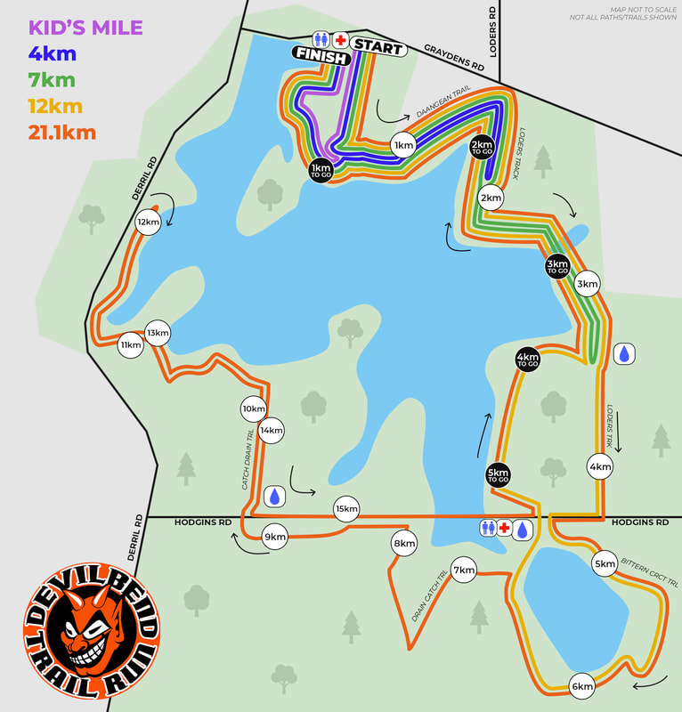
Combined Course Map - DEVILBEND 2023
Individual Course Maps plus elevation
|
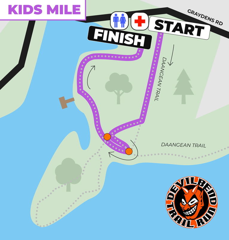
Kids Mile Course (1.6km)
Designed for kids aged 5-13, the "Magic Mile" begins at the top of the Daangean Trail heading southward. The course veers right, downhill, to the junction before turning left toward the water and turning back around. The course then traces back to the boardwalk and paved section before heading back up a little hill to the finish line adjacent to the starting area. The orange dots represent the marshall positions. |
|
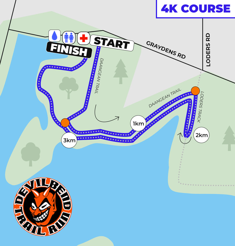
4km Course (7.106km)
A new addition to our course line-up in 2023, the 4km Course provides an approachable distance option to younger athletes, trail first-timers and those who have a need for speed! From the starting line at the top of the Daangean Trail, the course traverses the northern side of the reservoir to the intersection of Loders Track. Through the native lowland forest and grassy woodland, the course continues turns around at approximately 2km, and heads back to the cleared entry of the reserve. The final kilometre winds its way through to the boardwalk and paved pathway section before heading back up a little hill to the finish line adjacent to the starting area. The orange dots represent the marshall positions. |
|
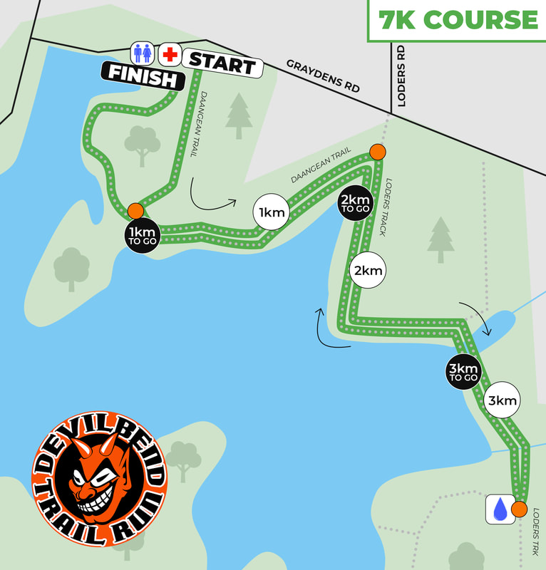
7km Course (7.106km)
The 7km Course makes the most of the scenic north east section of the Devilbend reserve. From the starting line at the top of the Daangean Trail, the course traverses the northern side of the reservoir to the intersection of Loders Track. Through the native lowland forest and grassy woodland, the course continues southward to the turn around loop, before turning around back up. The final kilometre winds its way through to the boardwalk and paved pathway section before heading back up a little hill to the finish line adjacent to the starting area. The orange dots represent the marshall positions. |
|
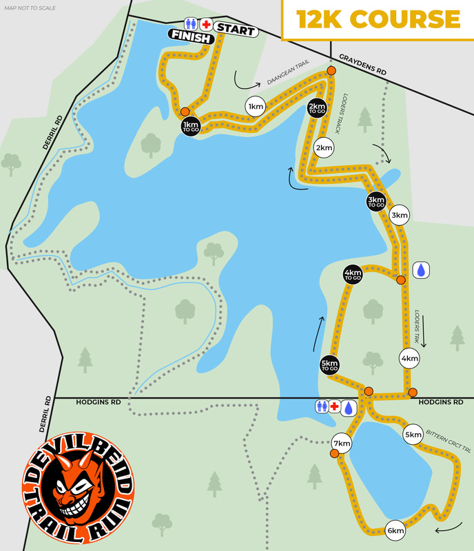
12km Course (12.183km)
The 12km Course gives participants the opportunity to explore the best of the Devilbend Reservoir park and the Bittern Reservoir loop. From the starting line at the top of the Daangean Trail, the course traverses the northern side of the reservoir to the intersection of Loders Track. Through the native lowland forest and grassy woodland, the course continues southward to Hodgins Road, crossing the dirt road before following a clockwise loop of the Bittern Reservoir. Entering the Devilbend park via the Stringy Track, the course heads northward, turning right before rejoining Loders Track. The remainder of the course follows the same path set out, before the boardwalk and paved pathway section in the final kilometre directs you to the small hill prior the finish line. The orange dots represent the marshall positions. |
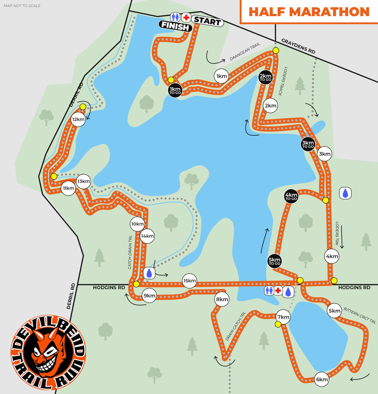
Half Marathon Course (21.097km)
The Devilbend Half Marathon Course is the full experience of the beautiful pristine surrounds of the Devilbend Natural Features Reserve.
From the starting line at the top of the Daangean Trail, the course traverses the northern side of the reservoir to the intersection of Loders Track.
Through the native lowland forest and grassy woodland, the course continues southward to Hodgins Road, crossing the dirt road before following a clockwise loop of the Bittern Reservoir, turning left at the Drain Catch Trail intersection.
The trail continues westward to the Hodgins road crossing back into the Devilbend park. Up the steepest hill of the reserve, the Catch Drain Trail then joins the southside of the path that follows the Devilbend Creek before crossing over to join the western side of the Reservoir Trail. Turning back around just shy of the 12km marker, the course heads down to Hodgins dirt road, turning left.
Entering the Devilbend park via the Stringy Track, the course heads northward, turning right before rejoining Loders Track. The remainder of the course follows the same path set out, before the boardwalk and paved pathway section in the final kilometre directs you to the small hill prior the finish line.
The yellow dots represent the marshall positions.
